Greening Aldwych Stop 1: 171 Strand, on the corner of Surrey Street
Start at 171 Strand, on the corner of Surrey Street. Stand so you can look down to the river, if possible. Or, return to the Greening Aldwych introduction.
By Fran Allfrey
Anglo-Saxon Aldwych
From the Anglo-Saxon period to until 1866-70 when Embankment was built and officially opened, the Strand was actually the road closest to the Thames. ‘Strand’, is the Old English word for shore.
Look south down Surrey Street, and imagine how the river would be breaking much closer, with stairs leading down from the flood walls to ferries waiting to get you across the waters.
'Aldwych' is another Old English toponym (a 'place name'), meaning ‘Old Market’ (think of Ipswich or other towns which have this name). Aldwych was a market village a few minutes from the gates of the city of Lundenwic to the east.
Even though it was less developed, the land was very much cultivated, whether for agriculture, for docklands, workshops, and homes. As we moved west, closer to Westminster, the marshier the land would become. The land where Westminster Abbey now stands was once essentially an island!
A whistle-stop through the 17th-19th centuries
Prior to the creation of Aldwych as it is today, there were criss-crossing smaller streets, including Wych Street, Holywell Street, Maypole Street or Newcastle Street, and Drury Court, White Hart Street. These streets had been in place more or less unchanged from the 16th century through to the late 19th century.
As you can see from the map, the Angl0-Saxon fields had been long replaced with dense housing.
And here's perhaps the most surprising thing about Aldwych today: it is the greenest it has been for at least 500 years!
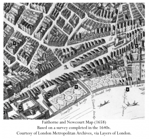
This is the Faithorne and Newcourt Map, published in 1658 and based on a survey completed in the 1640s (see the map on Layers of London).
Compare this map with the one below. The biggest differences between these two maps are the Embankment, and the changing layouts of Arundel House and Somerset House, which we will hear more about later. But, notice that the main street layout remains essentially unchanged over the course of 250 years.
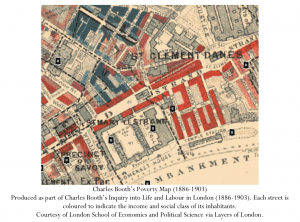
This second map is the Charles Booth's Poverty Map 1886-1903 (see the map on Layers of London). It was produced as part of Booth's 'Inquiry into Life and Labour in London'. Each street is coloured to indicate the income and social class of inhabitants:
- Black ‘lowest class, vicious, semi-criminal’
- Dark Blue – ‘very poor, chronic want’
- Light blue – ‘poor, 18s to 21s a week for a moderate family
- Pink – fairly comfortable
- Red – middle class, well to do
- Yellow – upper middle and upper class
Most of the streets around Aldwych are Dark Blue and Red.
Dark Blue streets signalled those places where people lived and worked hard: markets and housing were all jumbled together, as well as theatres. Some of you might know Clare Market, now a concrete thoroughfare in LSE, but even into the 19th century this was a place where sheep and cows were slaughtered, and fish sold.
The Red areas on Booth's map show the well-to-do lodgings of clerks and lawyers. Just like today, rich and poor lived only a street away from each other.
Directions to Stop 2: Clearing St Clements
Cross Surrey Street, and head east along Strand. Use two sets of traffic lights to cross Arundel Street. St Clement Danes is ahead to the left. Use the traffic lights to cross to St Clement Danes.