Layers of the Strand
Posted in 1700-1799, 1800-1899, 18th Century, 19th Century, 2010-2019, 20th Century, Editorial blog posts, Places, Stories, churches, coffee and tea houses, pubs and tagged with Cartography, Coffee Houses, Layers of London, MyStrand, get involved, map, project, strand, volunteer

Today, I have been time travelling.
I explored the farm around Trafalgar Square. I squeezed into a tiny top room in Devereaux Court to hear Isaac Newton speak. I paid a ferryman tuppence to take me to the floating coffee house on the Thames to look over the water at Somerset House.
This is all thanks to the Layers of London project, a map-based community history website created by Professor Matthew Davies (now based at Birkbeck), run by the team based at the Institute of Historical Research, with the help of a great many history enthusiasts from London and beyond.
Put most simply, you can do two things on the Layers of London site.
Firstly, you can explore London either using a modern map or by choosing one (or layering several!) of 12 historical maps. The oldest map, made in 1520, sadly does not cover all of the Strand, the eastern boundary is just about illustrated. The second oldest map, and my personal favourite that shows the whole Strand, is the Fairhorne and Newcourt, made in 1658.
What both of these maps show is the sheer amount of undeveloped space just a side-street away from the Strand in the sixteenth and seventeenth centuries. The 1658 map shows the area we now know as Trafalgar Square as an unassuming corner of an expanse of agricultural land. Layering both maps on top of one another, you can see the development of the area where the Royal Courts of Justice is: in just over 100 years, rows of tightly-packed houses intrude onto the green of what was once ‘Fickett’s Field’.
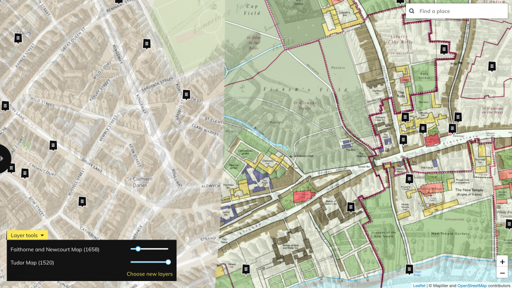
The Aldwych / Royal Courts of Justice area, shown on the 1520 Tudor Map, courtesy the Historic Towns Trust, layered with the 1658 Faithorne and Newcourt Map, courtesy of London Metropolitan Archives, via Layers of London.
As well as exploring the maps and playing with the transparency sliders to see how they fit on top of one another, absolutely anyone is able to add their own ‘layer’. These crowd-sourced entries show up as little speech bubbles on the maps. Click on them to see a preview, and then click again to see the full entries. Entries can include anything from potted histories of places (from the Roman period to the present day), images of the spot over time, and stories from people who have lived or worked in the area.
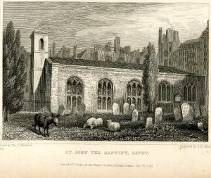
Engraving of the Savoy Chapel with a donkey and three sheep, by Thomas Hosmer Shepher, 1830, via Wikimedia Commons.
#/media/File:Savoy_Chapel_Thomas_Hosmer_Shepherd_1830.jpg)
A few of the entries on and around the Strand led me down a warren of Wikipedia and Google searches to find out more.
User Jim Stokoe has put together a short history of the Savoy Chapel. I can’t believe that having worked around the Strand for 11 years I have never ventured into this beautiful-looking space. Take a look at the entry to glimpse the gorgeous ceiling, which wouldn’t look out of place in the grandest of cathedrals. I’ll be venturing there later this week to take some photos for the Strandlines Instagram – be sure to take a look if you can’t go for a snoop around yourself.
The story of the eighteenth-century floating coffee house on the Thames had me daydreaming of a Waterloo sunset on the river itself. Just imagine taking in the view, hot chocolate in hand, the light adding glitter to the grey ripples. User Mike Scopa has uploaded several images of the so-called ‘folly’ for us to enjoy.
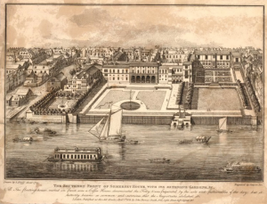
Somerset House, c.1720, with the coffee house in the Thames visible to the left, British Museum via Layers of London.
His note that “loose and disorderly ladies were admitted and unrestrained drinking and dancing went on until the early hours” was enough to send me looking up the price of a ferry (in 1770, fourpence would get you from one side to the other – so perhaps tuppence would be enough to get halfway?).
Another coffee house, also entered onto the map by Mike Scopa, was once nestled in the easternmost corner of the Strand. The Grecian Coffee House in Devereux Court “hosted meetings and lectures by the most famous scientists of the age, including Isaac Newton, President of the Royal Society, and Dr Edmond Halley, the astronomer”, as well as assorted “wits and poets” from the seventeenth to the nineteenth centuries. Now it’s a pub, one of many along this little side-street that I’ve wandered into post lectures – and I wonder whether in 150 years someone might add a note about the English Literature PhD students who drank there!
Featured image: the 1940s-1960s OS Map, courtesy of the National Library of Scotland, layered with the 1520 Tudor Map, courtesy the Historic Towns Trust, via Layers of London.
Can you help add layers to the Strand?
Compared to other parts of London, the Strand is somewhat under-populated with stories and photographs from across the ages.
So Strandlines have teamed up with Layers of London to encourage you – yes, you reading this! – to add your personal stories and memories, or favourite histories, to the map. You can find out how to do just that on the Layers of London site (select the plus sign or ‘Add Record’ from the menu).
Volunteer for Layers of London and Strandlines this summer!
We’re also looking to recruit a volunteer to work closely with both the Strandlines and Layers of London teams to delve into some archival research about places on the Strand, and fill this lovely map with engravings, paintings, documents, and more. You’ll get access to various archives, support from both teams, and travel expenses reimbursed. Take a look at our volunteer Strandlines Layers of London Brief, and if you would like to be involved, or would just like to find out more, don’t hesitate to be in touch.
Applicants should send an informal email to amy.todd@sas.ac.uk explaining their interest in the role and relevant skills/experience. Applicants will be contacted on the 24th May if successful for an informal meeting with the project team.

[…] of gout). This Tom’s was tucked on the corner of the Strand and Devereaux Court. The rival Grecian Coffee House opposite boasted Sir Isaac Newton, Sir Hans Sloan and Dr Halley, calculator of the orbit of the […]
I’ve got an original map of the Trafalgar Square area when it was stables/ mews.
Mews being where birds were kept ??
C 1810. Does anyone know it? I will try to turn it up